Highway 17 Wildlife Crossing – Second Big Step
A Second Big Step
This article originally appeared in our newsletter, Landmarks, Spring 2014
 In February the Land Trust took the first big step towards building a Highway 17 wildlife crossing by buying a ten-acre property at Laurel Curve. Two months later we took a second, much bigger step towards turning this dream into reality: we signed an option to buy a 280-acre adjoining property. We have until November to figure out financing and raise money to complete this transaction. (Yes, your donation will help!)
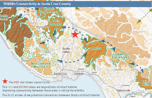
The property is currently undeveloped, 280 acres of mixed forests and creeks, an ideal corridor between the larger blocks of undeveloped land to the north and south. (See the map on page 2). Our Conservation Blueprint identified this property as having the most development potential in the Santa Cruz Mountains, with the possibility that dozens of homes could be built there. The resulting roads, traffic, lights, fencing, and pets, would deter use by wildlife. The likely presence of animals like goats could actually set up a kind of “depredation trap,” essentially tempting mountain lions with goats that lead to depredation permits—the largest cause of mountain lion deaths in the state (vehicle collisions are the second largest cause). The development of the property could even discourage Caltrans from investing in the wildlife crossing.
That would be a shame because research by biologist Tanya Diamond shows that Laurel Curve is the best possible location for a Highway 17 wildlife crossing in Santa Cruz County. She should know because she checked out every culvert along the highway. Each one she looked at was either too small, or located in heavily developed areas. She concluded that Laurel Curve is the best possible location—by a long shot.
The highway there is built over a large natural drainage, an ideal place to install a large box culvert beneath the highway. Research by the Santa Cruz Puma Project’s biologist, Chris Wilmers, shows both extensive use of the area by mountain lions – and the deaths of three of them in recent years. Wilmers called the Laurel Curve area “the best opportunity for maintaining puma connectivity across Highway 17 in Santa Cruz County.”
A wildlife crossing would not only benefit wildlife, but would also make safer one of the state’s most dangerous highways—the fourth most dangerous according to Caltrans. Caltrans has designated the entire highway a “safety corridor,” which is why you see almost continuous work to make it safer. Our many conversations with Caltrans show a keen interest in the project—assuming we can successfully protect the properties on either side.
Because of the tight timeline, our funding plan depends on securing a combination of grants and loans to purchase the property. We tentatively plan on repaying these loans through donations and reselling up to three parcels, subject to conservation easements. The easements will restrict development, so as not to impact the wildlife corridor. This kind of innovative financing is the new reality facing conservation organizations (see Terry Corwin’s article on page three).
In 2011, as we completed work on our Conservation Blueprint, we were aware that developing wildlife connectivity across Highway 17 was one of its most daunting goals. Well, we told ourselves, it’s a 25-year plan. Maybe someday. It is amazing and wonderful that, just three years later, this project is within our grasp.
We have gotten this far because of everyone who donated to our Campaign to Protect 10,000 Acres, which created our first-ever Opportunity Fund. Without that fund, we would not have the nerve—nor the ability—to secure the loans we need to take the first big steps toward this dream. Your support now will help us continue on this path and see this project to completion.
•